On the 27th of last month, the government began a ‘conditional approval’ for Google to export high-precision map data of South Korea abroad.
The South Korean government (comprising 9 ministries including the Ministry of National Defense, Ministry of Foreign Affairs, and National Intelligence Service, under the ‘Deliberative Body for the Export of Survey Results Abroad’ affiliated with the Ministry of Land, Infrastructure and Transport) broke its prohibition policy, which had been in place for approximately 19 years, and initiated a ‘conditional approval’ allowing Google to export high-precision map data of South Korea abroad by February 27, 2026.
The government stated its position: "We expect this to be evaluated as a model that finds a balance, providing the benefits of global technology services to citizens and industries while protecting information sovereignty and national security."
▲ Conditions for Opening Google Maps
① Google’s domestic partner company must process the data first on servers located in South Korea, and only data approved by the government can be exported abroad.
⓶ Military bases or key national security facilities must be rendered invisible in satellite and aerial photographs.
⓷ Restrictions on the display of latitude and longitude coordinates for Korean territory, and exclusion of security-sensitive information.
⓸ Establishment of a system for the government to request emergency data control in the event of a national security crisis.
⓹ A responsible representative who can maintain constant communication with the government must be stationed in South Korea.
Many analyze that this decision by the government was strategically made in terms of resolving customs negotiations or digital trade barriers with the United States, in response to claims of discrimination by the South Korean government against U.S. companies following the recent Coupang incident, including an investigation initiated under Super 301.
History of Mapmaking
In Japan, during the early 1800s of the late Edo period, Inō Tadataka spent 17 years conducting actual surveys across Japan to create the precise ‘Dai Nihon Enkai Yochi Zenzu’ (Complete Map of the Coastal Areas of Great Japan). At the time, the Shogunate classified it as a state secret and strictly prohibited its external leakage.
The Daedong Yeojido, completed in 1861 by Kim Jeong-ho, a Silhak scholar and geographer of the late Joseon Dynasty, was astonishingly accurate. The royal court at the time recognized its superiority and used it for administrative purposes.
During the Korean War, Chosin Reservoir was marked as Jangjin Lake on a U.S. military map. This was the result of producing an English version based on maps created by the Japanese. The Battle of Chosin Reservoir is known as the Battle of Jangjin Lake in the United States.
Initially, maps were created relying on human footsteps and visual estimation. Subsequently, surveying instruments were used, and in modern times, aircraft and drones have been employed for photography. Finally, precision maps are created using high-resolution photographs taken by satellites from space, beyond the reach of national sovereignty.
Recent precision strikes by aircraft during the U.S. and Israeli airstrikes on Iran demonstrate that maps are not just simple drawings but represent real-time data. ‘Digital Twins,’ combining GPS, satellite information, and terrain data, are determining the outcome of modern warfare.
Google Maps currently provides services in over 250 countries and regions (prohibited or restricted in countries like China, North Korea, Sudan, Syria, and Iran) and is the world's largest navigation platform with approximately 1.8 billion monthly users.
In addition to Street View cameras, it collects data using satellite and aerial imagery and over 1,000 third-party data sources (local governments, users, etc.).
Cases of the United Kingdom and Japan
By opening its precise data from the Ordnance Survey to private platforms like Google, the UK has driven innovation in fintech and logistics based on this data.
Japan, facing similar security concerns, has allowed Google access to its precise maps while establishing a ‘strategic data sharing’ system through cooperation with its domestic companies.
Google Maps' Service Competitiveness and Business Model
Google Maps is building a vast ‘Digital Twin’ ecosystem by combining a global data network with advanced AI technology, going beyond a simple map service.
Global Data Network: Google Maps provides information for over 200 countries and regions worldwide by combining multilayered data sources (satellite and aerial photography, Street View, real-time integration of public data from governments, data updates from over 500 million ‘local guides’ worldwide providing photos, reviews, business hour corrections, etc.).
AI-Driven Data Processing: The vast amount of collected ‘raw data’ is transformed into meaningful information through Google’s latest AI models (like Gemini) and machine learning algorithms.
Traffic Data: Google Maps uses a predictive model that combines past records with real-time signals for its traffic information.
Business Model & Operations
The most powerful revenue stream is the provision of APIs (Application Programming Interfaces) through the ‘Google Maps Platform’.
For example, ride-hailing services like Uber, delivery platforms, and logistics companies, for whom real-time route optimization and accurate location data are essential, pay substantial fees to Google for utilizing this infrastructure.
The second is ‘location-based advertising’ within the map. Google Maps combines users' search intent with their real-time location to display the most relevant commercial information.
Examining South Korea’s geospatial information industry ecosystem (2025 Geospatial Industry Statistics Survey):
▲ Total Revenue: 11.2836 trillion KRW, Total Businesses: 5,854 (being reorganized with a focus on small and medium-sized enterprises), Employees: 74,067, Operating Profit Margin: 2.8%
▲ Industries include geospatial equipment manufacturing (GPS receivers, drones, surveying equipment, LiDAR sensors), geospatial wholesale (map software package sales, imported survey and equipment supply), geospatial services (ground, aerial, and underwater surveying, mapmaking, geospatial consulting), and software development and information services (navigation apps Naver/Kakao, digital twin construction, AI-based commercial area analysis). This sector consists of a few large corporations like Naver and Kakao, and numerous small and medium-sized enterprises.
Strategies to Minimize Harm from Opening
Given Google’s overwhelming competitiveness and its globally established infrastructure, industrial damage is unavoidable in the short term. However, there is potential for the industry to leap forward through collaboration with Google.
Companies like Naver and Kakao must enhance their ‘locally focused’ services (e.g., real-time restaurant reservations, integration with local communities, detailed alleyway views) to increase user lock-in. Furthermore, a shared infrastructure should be established to allow small and medium-sized geospatial companies to utilize high-precision data affordably and securely.
Domestic startups should create an environment where their algorithms for autonomous driving, AR (Augmented Reality), and logistics optimization, developed based on Korean maps, can be immediately applied to global markets (New York, Paris, etc.) through Google Maps APIs.
It should be utilized as a tool to revitalize regional economies by enabling foreign tourists to seamlessly use domestic public transportation and walking navigation through the familiar Google Maps, thereby dispersing tourism demand from Seoul to provincial towns.
A collaborative model should be established to lead international standards in fields such as Digital Twins, Smart Cities, and Urban Air Mobility (UAM) by combining Google's cloud and AI technologies with South Korea's precise spatial data.
Conclusion: Towards Fair Contribution and Digital Alliance
The opening of map data is not an end, but a beginning. South Korea must now move beyond hiding behind the notion of ‘map sovereignty’ and consider how to transform open data into a weapon for its industries.
Simultaneously, the government's next task is to establish a ‘fair contribution’ model where Google pays taxes appropriately in South Korea commensurate with the immense profits it gains and shares its domestic market and technology.
It is hoped that this decision, which ends a 20-year deadlock, will be the prelude to a true ‘digital alliance’ that propels South Korea to become a central axis of the global digital economy.

◆ Dr. Shin Dong-chun
Ph.D. in Public Administration, Chairman of the Global Aerospace Industry Association, Representative of the National Unification Alliance. After passing the 21st Higher Civil Service Examination, he had a career in public service, followed by extensive activities as a corporate CEO, university professor, media contributor, author, and Chairman of the Global Aerospace Industry Association.

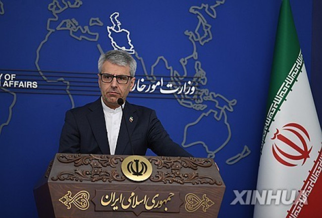 Iranian Foreign Ministry: "Continuing Message Exchanges with the U.S. and Activities of Mediating Countries"
Esmaeil Baghaei, Spokesperson for the Iranian Ministry of Foreign Affairs [Xinhua, Yonhap News file photo]Esmaeil Baghaei, spokesperson for the Iranian Ministry of Foreign Affairs, stated on the 26th
Iranian Foreign Ministry: "Continuing Message Exchanges with the U.S. and Activities of Mediating Countries"
Esmaeil Baghaei, Spokesperson for the Iranian Ministry of Foreign Affairs [Xinhua, Yonhap News file photo]Esmaeil Baghaei, spokesperson for the Iranian Ministry of Foreign Affairs, stated on the 26th
 President Yoon: "Do You Think You Are Safe from the Special Counsel?"... Final Statement Video Released
President Yoon Suk Yeol rebuking the special prosecutor on the 24th. [Court video / @birds_justice X account subtitle GIF] A video of President Yoon Suk Yeol's closing statement at his trial rega
President Yoon: "Do You Think You Are Safe from the Special Counsel?"... Final Statement Video Released
President Yoon Suk Yeol rebuking the special prosecutor on the 24th. [Court video / @birds_justice X account subtitle GIF] A video of President Yoon Suk Yeol's closing statement at his trial rega
 President Yoon, regarding the first-instance ruling on the Public Official Election Act: “An excessive political verdict that distorts the facts… We will appeal immediately.”
The first-instance sentencing hearing for President Yoon Suk Yeol regarding violations of the Public Official Election Act is being broadcast live at Seoul Station on the 27th. [Photo=Yonhap News]Pres
President Yoon, regarding the first-instance ruling on the Public Official Election Act: “An excessive political verdict that distorts the facts… We will appeal immediately.”
The first-instance sentencing hearing for President Yoon Suk Yeol regarding violations of the Public Official Election Act is being broadcast live at Seoul Station on the 27th. [Photo=Yonhap News]Pres
 WSJ: "SK Hynix ADR Premium Is a Sign of AI Trading Overheat"
Advertisement for SK Hynix ADR listing in New York's Times Square [Reuters=Yonhap News file photo]The Wall Street Journal (WSJ) has pointed out that the price of SK Hynix’s American Depositary Recei
WSJ: "SK Hynix ADR Premium Is a Sign of AI Trading Overheat"
Advertisement for SK Hynix ADR listing in New York's Times Square [Reuters=Yonhap News file photo]The Wall Street Journal (WSJ) has pointed out that the price of SK Hynix’s American Depositary Recei
 'Godfather of Japanese Mystery Novels' Keigo Higashino Passes Away After Battle with Cancer at 68
Famous Japanese mystery novelist Keigo Higashino [AFP=Yonhap News]It has been belatedly reported that Keigo Higashino, the "godfather of Japanese mystery novels" and author of bestsellers such as "The
'Godfather of Japanese Mystery Novels' Keigo Higashino Passes Away After Battle with Cancer at 68
Famous Japanese mystery novelist Keigo Higashino [AFP=Yonhap News]It has been belatedly reported that Keigo Higashino, the "godfather of Japanese mystery novels" and author of bestsellers such as "The
 [Park Pil-kyu Security Column] To the Ignorant Trying to Clothe a Beast in Sheep's Clothing
Rep. Kim Byung-joo of the Democratic Party of Korea [Photo=Yonhap News]“The Air Force Academy doesn't teach you how to fly a plane!” “The Army, Navy, and Air Force academies are exactly the
[Park Pil-kyu Security Column] To the Ignorant Trying to Clothe a Beast in Sheep's Clothing
Rep. Kim Byung-joo of the Democratic Party of Korea [Photo=Yonhap News]“The Air Force Academy doesn't teach you how to fly a plane!” “The Army, Navy, and Air Force academies are exactly the
 [Issue Diagnosis] Two Effects of the Election Petition Review
 [Photo] Evidence of Election Fraud Flooding U.S. Media… Trump Had 2.7 Million Votes Stolen
 [Video] U.S. Semiquincentennial Air Show... 'Art in the Sky' streaks across New York
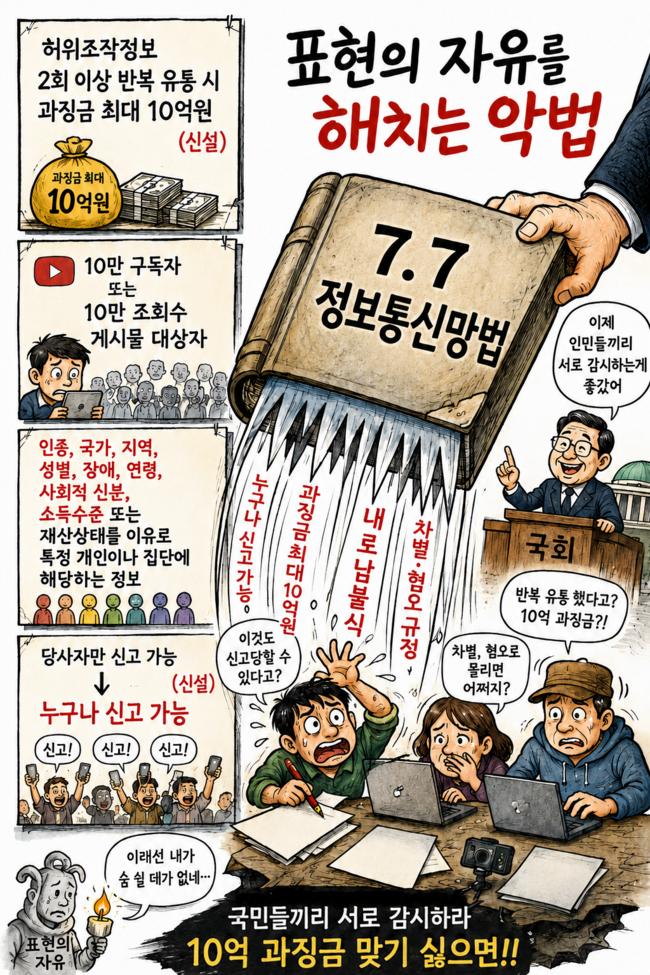 [Editorial Cartoon] A Draconian Law That Undermines Freedom of Expression

 List
List