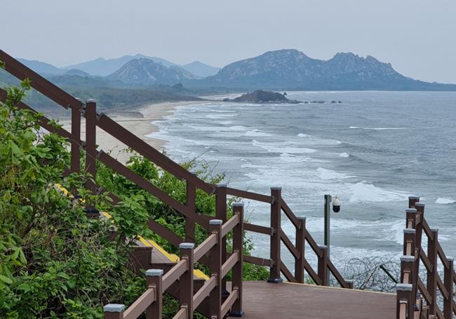
"DMZ Peace Road," where visitors can witness the ecological, cultural, and historical resources of the Demilitarized Zone border area and personally experience the preciousness of peace. [Photo = Reporter Lim Yo-hee]
"DMZ Peace Road" was opened to the public in 2018, 65 years after the Armistice Agreement. The Demilitarized Zone (DMZ) is the world's only site of division, a treasure trove of natural ecosystems, and a place where the risk of military conflict between North and South Korea has always existed.
However, in 2018, through an agreement between North and South Korea, it was decided to transform the Demilitarized Zone into a zone of practical peace, and it was opened to the public. Peace Road allows visitors to witness the ecological, cultural, and historical resources of the Demilitarized Zone border area and personally experience the preciousness of peace, earning it the title of "Top 1 Tourist Destination in Korea Foreigners Want to Visit." This is because the Korean Peninsula DMZ is the only legacy of the Cold War in the world that has been maintained for over 60 years.
Top 1 Tourist Destination in Korea Foreigners Want to Visit
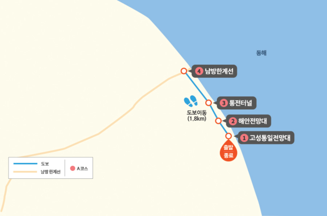
Among the 10 border areas – Ganghwa, Gimpo, Goyang, Paju, Yeoncheon, Cheorwon, Hwacheon, Yanggu, Inje, and Goseong – the Goseong course, which belongs to the eastern front line, allows access up to the Southern Limit Line.
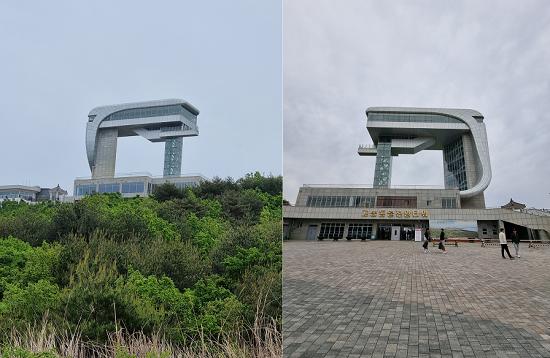 The back (left) and front of the Unification Observatory. "DMZ Peace Road" visitors are granted the privilege of seeing the back. Until now, the northernmost area accessible to civilians was the Goseong Unification Observatory. However, it is now possible to walk along the coast through the exit of "DMZ Peace Road" to the very edge of the Demilitarized Zone. This means one can travel 1612 meters further than from the Goseong Unification Observatory.
The course consists of the Goseong Unification Observatory → Coastal Observatory → Tongjeon Tunnel → Southern Limit Line, and is designed to allow visitors to experience both the beauty of the East Sea and the reality of division simultaneously.
Peace Road, as its name suggests, is not an easy journey from the start. After completing the entry report at the Unification Security Park and undergoing military verification at the Jejine Checkpoint, entry to the Goseong Unification Observatory is finally permitted. Since the entire process takes a considerable amount of time, it is advisable to set out with ample time. As 20 reserved participants gather to depart simultaneously, being late for the assembly time (10 AM, 2 PM departures) means immediate disqualification.
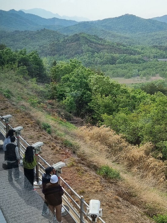
Photography is strictly prohibited within the DMZ, but it is exceptionally allowed at the coastal observatory at the entrance. Visitors diligently take commemorative photos against the backdrop of the blue sea, thinking, "When else will we get to see this?"
Two soldiers and two guides accompany the Peace Road trek. Before departure, the guides earnestly warn participants not to touch the barbed wire fence under any circumstances. In the past, soldiers stood guard 24 hours a day, but now sensors serve that purpose. Touching the fence will immediately trigger the dispatch of military forces, leading to the suspension of the tour.
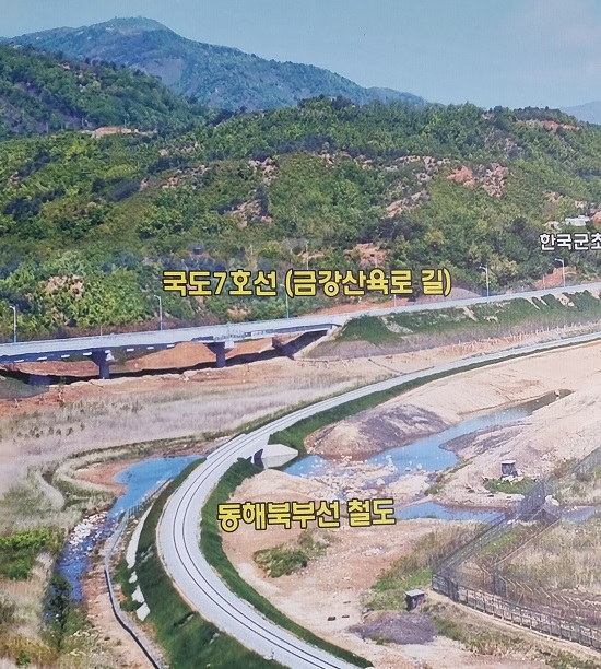
There is a road, but we cannot go! Donghae Bukbu Line, Geumgangsan Roadway
After passing the coastal observatory, one encounters the Donghae Bukbu Line railway passing through the Tongjeon Tunnel. The Donghae Bukbu Line is a railway that connects Yangyang to Wonsan, a distance of 192 km, in a single line. Damaged during the Korean War, North and South Korea agreed to restore 25.5 km from Jejine Station to Geumgangsan Youth Station in North Korea and conducted test runs in 2007.
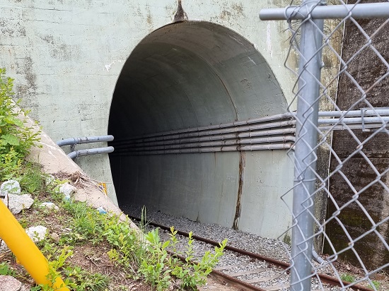 After passing the coastal observatory, one reaches the Tongjin Tunnel through which the Donghae Bukbu Line railway passes. [Photo = Reporter Lim Yo-hee]
 [Ministry of National Defense photo]
The restoration project of the Donghae Bukbu Line had instilled great hope of being able to travel by train not only across the Korean Peninsula but also to Europe. However, as inter-Korean relations rapidly cooled the following year, the project was abandoned.
Next to the railway runs the "Geumgangsan Roadway," an extension of National Route 7. It is hard to believe that as many as 2 million tourists once traveled along this road for excursions to Geumgangsan; the road is now desolate and lonely.
The waves crash indifferentlessly, but what has overwhelmed them? The wild roses, clinging close to the ground, cautiously reveal their red hues. The visitors orderly pass through Songhyeon 1 and 2 Bridges, the northernmost bridges in South Korea. Beneath the bridges, heavy iron gates are lowered to prevent tanks from entering. The gates are opened only during heavy rains to prepare for floods.
Imagining the Northern Limit Line with Our Hearts
The Peace Road tour concludes at the "Southern Limit Line," 1612 meters further in from the Unification Observatory. Although one wishes to go at least as far as the "Songdo Observatory" right in front, it is not possible. Haegumgang protruding into the East Sea, the horse-head peninsula, and the scattered islands on the sea appear within reach, but cannot be visited.
 Coastal Observatory. [Photo = Reporter Lim Yo-hee]
 On a clear day, standing at the Goseong Unification Observatory, one can visually confirm the foothills of Geumgangsan. The Goseong GP is located on the leftmost peak in the photo. Going down the slope next to it, there is a North Korean guard post where the terrain rises once. Behind it, the faintly visible mountain range is Geumgangsan. From left to right: Ilchulbong, Chaehwabong, Yukseonbong, Jipseonbong, Sejonbong, Oknyeobong, Sinseondae... [Photo = Reporter Lim Yo-hee]
The Northern Limit Line, said to be at the foot of Guseonbong (Camel Rock), the easternmost peak of Geumgangsan, and the lake "Gamho," imbued with the legend of the fairy and the woodcutter below it, can only be imagined.
The Goseong course has a capacity of 20 people per session. It operates five days a week: Tuesday, Wednesday, Friday, Saturday, and Sunday, with two sessions per day (10 AM and 2 PM). The participation fee is 10,000 won, but souvenirs are provided after the tour, making the fee largely symbolic. The course operates from April 17th to the end of November, excluding the peak summer and winter seasons.
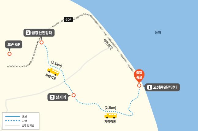
After completing the Goseong course, consider taking on the nearby Geumgangsan Observatory course. It also starts at the Goseong Unification Observatory, but it involves a vehicle ride to the Geumgangsan Observatory beyond the Southern Limit Line. While the Goseong course, due to its nature requiring considerable walking, is for individuals aged 7 and above, the Geumgangsan Observatory course has no age restrictions as it utilizes a vehicle.
▲ Can one truly not be armed in the Demilitarized Zone?
The Demilitarized Zone on the Korean Peninsula, according to the 1953 Armistice Agreement, refers to a buffer zone with a width of 4 km, 2 km each north and south of the Military Demarcation Line (MDL). However, in reality, it is the most heavily armed zone, with opposing forces facing each other at their closest points while armed.
 The "DMZ Peace Road Goseong Course (top) and Geumgangsan Course."
Reporter Lim Yo-hee
 [Special Feature - National Investigation on Deprivation of Political Rights ①] A National Investigation without Eyewitnesses is like 'a steamed bun without red bean paste'
On the 16th, Lee Young-don TV exposed the reality of the June 3rd local elections through the direct experience of a current National Election Commission (NEC) official. [Photo=Screen capture from Lee
[Special Feature - National Investigation on Deprivation of Political Rights ①] A National Investigation without Eyewitnesses is like 'a steamed bun without red bean paste'
On the 16th, Lee Young-don TV exposed the reality of the June 3rd local elections through the direct experience of a current National Election Commission (NEC) official. [Photo=Screen capture from Lee
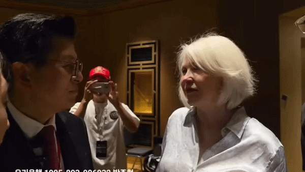 Hwang Kyo-ahn, Leader, Meets with US 'Election Fraud Warrior' and Says, "Korea is in Crisis, Please Intervene, Trump"
Hwang Kyo-ahn, leader of the Freedom and Innovation Party (left), speaks with Tina Peters, a former Mesa County clerk in Colorado and a "election integrity warrior" who has fought against election fra
Hwang Kyo-ahn, Leader, Meets with US 'Election Fraud Warrior' and Says, "Korea is in Crisis, Please Intervene, Trump"
Hwang Kyo-ahn, leader of the Freedom and Innovation Party (left), speaks with Tina Peters, a former Mesa County clerk in Colorado and a "election integrity warrior" who has fought against election fra
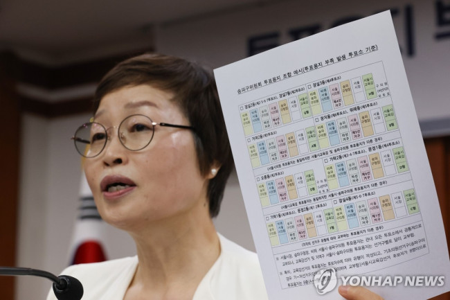 Fact-Finding Committee: "Total mismanagement of election administration... Recommend referral for investigation of Noh Tae-hak and others."
On the 19th, Cho Hyun-wook, chairman of the 'Investigation Committee for the Ballot Paper Shortage Incident', briefs the final investigation results at the National Election Commission in Gwacheon, Gy
Fact-Finding Committee: "Total mismanagement of election administration... Recommend referral for investigation of Noh Tae-hak and others."
On the 19th, Cho Hyun-wook, chairman of the 'Investigation Committee for the Ballot Paper Shortage Incident', briefs the final investigation results at the National Election Commission in Gwacheon, Gy
 Prosecution Demands 2 Years Imprisonment and Fine for Lee Hwa-young for Perjury and Splitting Donations
Former Gyeonggi Province Vice Governor Lee Hwa-young, who appeared as a witness at a hearing related to the Ssangbangul North Korea remittance case held by the parliamentary special committee for the
Prosecution Demands 2 Years Imprisonment and Fine for Lee Hwa-young for Perjury and Splitting Donations
Former Gyeonggi Province Vice Governor Lee Hwa-young, who appeared as a witness at a hearing related to the Ssangbangul North Korea remittance case held by the parliamentary special committee for the
 Is the JoongAng Ilbo's dominance crumbling? With no money, JoongAng Ilbo finally files for workout program.
There is intense interest in whether a major seismic shift will occur in the South Korean newspaper industry, potentially toppling the long-standing dominance of the JoongAng, Chosun, and Dong-A Ilbo
Is the JoongAng Ilbo's dominance crumbling? With no money, JoongAng Ilbo finally files for workout program.
There is intense interest in whether a major seismic shift will occur in the South Korean newspaper industry, potentially toppling the long-standing dominance of the JoongAng, Chosun, and Dong-A Ilbo
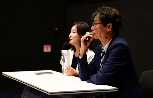 [Photo] 'The Movie Asks, The Book Answers'... Kim Gyuna × Jeong Gwangje, Talk Show Held at Lacksper Film Festival on the 19th
Artist Kim Gyu-na (left) and artist Jeong Kwang-je held a talk show titled "Movies Ask, Books Answer" on the second day of the Lumper International Film Festival, on the 19th, at the Seoul Film Center
[Photo] 'The Movie Asks, The Book Answers'... Kim Gyuna × Jeong Gwangje, Talk Show Held at Lacksper Film Festival on the 19th
Artist Kim Gyu-na (left) and artist Jeong Kwang-je held a talk show titled "Movies Ask, Books Answer" on the second day of the Lumper International Film Festival, on the 19th, at the Seoul Film Center
 [Photo] Current status of Chairman Hwang Kyo-ahn and lawyer Park Joo-hyun attending the US election fraud fighter summit
Lawyer Park Joo-hyun with lawyer Peter Ticktin, who was pardoned by U.S. President Donald Trump. [Facebook]Hwang Kyo-ahn, leader of the Liberty and Innovation Party (second from left), informing about
[Photo] Current status of Chairman Hwang Kyo-ahn and lawyer Park Joo-hyun attending the US election fraud fighter summit
Lawyer Park Joo-hyun with lawyer Peter Ticktin, who was pardoned by U.S. President Donald Trump. [Facebook]Hwang Kyo-ahn, leader of the Liberty and Innovation Party (second from left), informing about
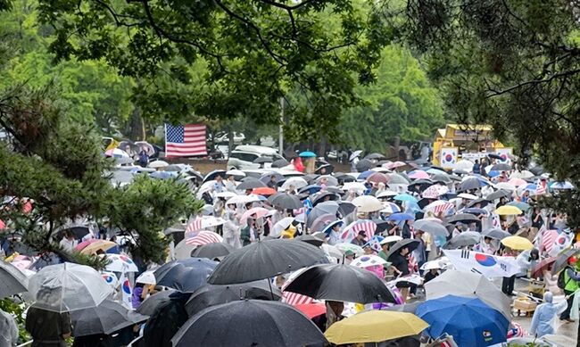 [Cho Yang-kun Column] The reason for the ever-increasing heat at Olympic Park
At noon on the 20th, citizens chanted "Re-election for fraudulent elections, same-day voting and manual counting!" at Olympic Park in Seoul, even amidst heavy rain. ⒸHanmi Ilbo The fervor of th
[Cho Yang-kun Column] The reason for the ever-increasing heat at Olympic Park
At noon on the 20th, citizens chanted "Re-election for fraudulent elections, same-day voting and manual counting!" at Olympic Park in Seoul, even amidst heavy rain. ⒸHanmi Ilbo The fervor of th
 [Video] 'Trump's close friend' Lindell "I will inform Trump about South Korea's fraudulent election"
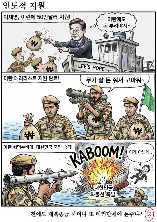 [Editorial Cartoon] Humanitarian Aid

 List
List